This time around the weather wasn’t going to be as cooperative; a problem most of the US’ totality path suffered. In the weeks and days leading up to the 2024 Solar Eclipse, I monitored the cloud forecast like so much of the country did, and it seemed that my original target of Erie, PA, along with most of the Northeast save for Maine and Vermont, would inevitably have some degree of cloud cover ranging from 50-90%. The nearest guaranteed clear sky to me was going to be Indianapolis, which was simply too far away to be feasible on short(ish) notice, especially considering the outbound traffic (18hrs) will be around double the inbound travel time (9hrs). Disappointed, I chose not to travel more than a day-trip distance from home for this eclipse due to the equally disappointing totality centerline weather.
Following this late, final decision to not travel far out of state for the eclipse, I had other interesting eclipse viewing options on my radar. Top of my list was an event at NASA’s Wallops Flight Facility, which not only would feature telescopes to view the solar surface up close, but also to watch three sounding rocket launches into the moon’s shadow during different phases of the eclipse. I’ve watched livestreams of Wallops launches for quite a long time, and have even seen and photographed a few visible from my backyard at night, but had never made it down to the launch facility. I considered this, since the weather in the DC and Chesapeake regions seemed about the same, however ultimately decided agains it because I didn’t think the amount of driving time and inconvenience merited seeing three small and fast rockets launch in daylight with over a 5+% reduction in eclipse visibility - DC saw 89% eclipse, and up over 90% if you were in Leesburg, VA, while Wallops was down to 84% thanks to just an extra ~2hrs away from the totality line.
While making these very overthought choices, I saw an article from the 2017 eclipse with people viewing from the National Mall - the Smithsonian National Air and Space Museum was hosting an eclipse watching event on the Mall agin this year, but that was beside the point for me - I decided that if I couldn’t see totality again this year, and knowing that anything less than totality is honestly disappointing, then the story should be more focused on the people watching the eclipse.
I made my way in to the District just as the eclipse was starting, and knew I was in good company when I saw people on every streetcorner with eclipse glasses or cameras. Entering the street from one of my usual parking spots in Federal Triangle, workers from the offices in the Ronald Reagan Building were gathered in Woodrow Wilson Plaza watching the moon progress over the sun. This included Customs and Border Protection Officers that work in the office and Global Entry Enrollment Center inside the Reagan Building. Walking toward the National Mall, people were gathered on benches on the grounds of the National Museum of African American History and Culture.
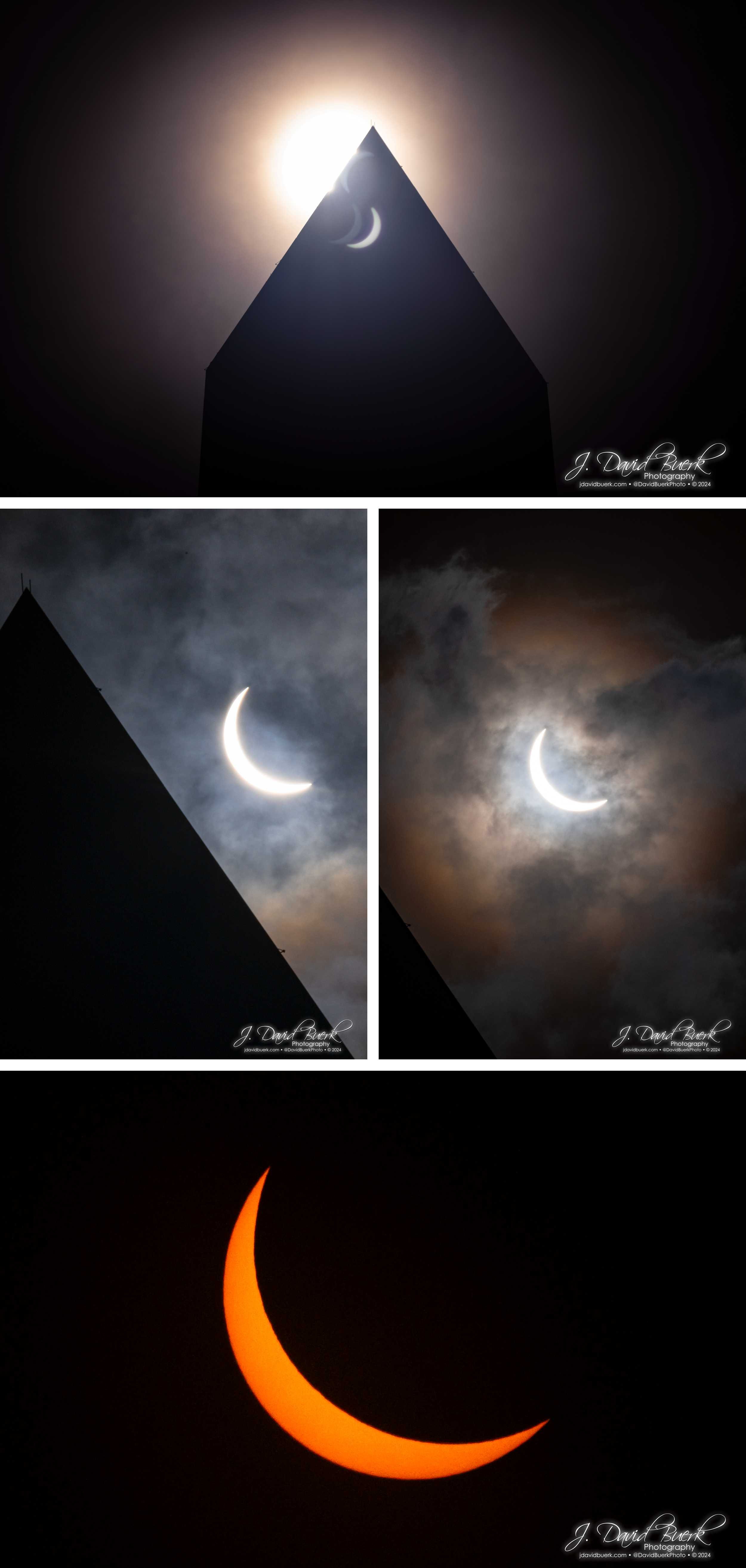
As I stepped onto the National Mall, it was clear a lot of other photographers had my same idea for setup location: the tip of the Washington Monument’s shadow, with the aim of capturing the eclipse and monument in the same image.
After I’d found my spot, set up my camera, and was dialing in my equipment, a couple other nearby photographers asked if I was with Reuters or AP or another wire or media agency, because they said another Reuters photographer had just shot a photo from this location with my exact same jury-rigged contraption of modifying eclipse glasses to fit over my lens (rather than using an expensive and long-sold-out dedicated solar filter - eclipse glasses are tiny solar filters, just not in the correct size for mounting to a lens assembly). If I had been surely planning to visit totality again, I’d have purchased a dedicated solar filter weeks prior, but it wasn’t looking likely due to seasonal weather even then. Instead I had built the simple contraption at home and left mounting for on-site. If I was thinking like a wire photographer, I must be thinking the right way.
The time of maximum eclipse was fast approaching and finally here, and the sun was moving as quickly across the sky as the moon progressing before the sun - mid-way through the peak of the eclipse I had to move positions twice to keep the sun visible from hiding behind the Washington Monument. Peak was immediately obvious to me, with the same uncanny and hair-raising dip in luminosity and vibrant change of color rendering leading up to totality in 2017. It’s difficult to visualize in a picture, but it feels like you’re wearing sunglasses when you aren’t, and images during this short time appear as though they have been HDR-to-SDR overprocessed as was popular in the 2000s-2010s, with soft shadows.
I captured the moon coming and going, with and without the solar filter. Although solar photography gets all the talk, I think my standard un-filtered photography of the 2024 Solar Eclipse, with DC’s partly cloudy skies above the Washington Monument, are the highlight. To me these images feel ancient; reminiscent of sights societies have witnessed through the ages beside their great monuments.
Once the sun was fully visible again, I had clear view of something I’d been noticing while shooting the eclipse: I was capturing sun spots.
Once the eclipse had passed DC, and the crowds had left the Mall, I decided to enjoy the weather and enjoy the nearby sights - I can’t remember if I’ve ever actually stood under or touched the Washington Monument before, but I did today. Like The Gateway Arch, it increasingly feels like a structure that shouldn’t be capable of freely standing so tall the closer you get to its base.
This 2017 Solar Eclipse was sadly nowhere near as memorable as my 2017 experience of Totality, but after seeing the results from many spots across the US, including Cleveland and Erie, the two areas I had eyeballed for travel, it seems I made the right call in staying local, and would have ended up even more disappointed had I committed to the travel. At least this way I can say I’ve experienced a solar eclipse both in and outside of totality now.
Looking forward to 2044! Truly fortunate would be Iceland in 2026!


